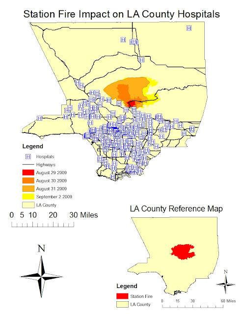
The map shown above titled Station Fire Impact on LA Hospitals, shows the spread of the Station Fire from late August to early September. This map is a thematic map, as it focuses on the proximity and impact of the fire on one single theme: hospitals. Additionally, major highways are shown in order to provide the viewer perspective on location within Los Angeles County. The aspect used within the thematic map is hospitals, specifically those under threat as a result of the fire spreading. As evidenced above, there are several hospitals that were directly within the fire boundary. Below the thematic map is a reference map that shows the extent of the Station Fire within Los Angeles County.
The theme of the map introduced here is Los Angeles County hospitals impacted by the Station Fire. From this map, several hypotheses arise. First, from the time lapse of the Station Fire, one can hypothesize that the fire moves northward. The reason for this is a combination of the wind direction and increasing elevation. Though the digital elevation model is not provided in the above maps, basic geographic knowledge of Southern California will support this claim. Similarly, wind direction is not readily discernable from the maps above, however, the wind direction can be obtained from literature sources.
Secondly, an additional hypothesis is that Los Angeles County Hospitals were not forced to evacuate their patients because the Angeles Forest was north of most hospitals in close proximity. Thus, as the fire expanded, it did so away from the hospitals. If however, the fire was not put out in the timely manner it was, several hospitals north of the epicenter would have required evacuation. This is due to the spread of the fire in both east and west directions, where several hospitals are located.
Another hypothesis is that due to road closure from the Station Fire, residents in smaller communities north of the Angeles Forest were unable to reach their local hospitals. Since precautionary evacuation measures were taken, these communities were helped by medical responders and evacuation teams. As a result the danger of people needing and unable to reach medical care was averted through careful planning.
From the thematic map created, it is evident that the Station Fire took place in an area of low population density. This finding is inferred since the number of hospitals in a given area is directly proportional to the population. The region in which the Station Fire occurred is away from major highways and hospitals, as it was in a forest. Though some communities were affected, major population centers like Downtown, West LA, and the Southbay were unaffected. Moreover, a thematic map like the one displayed brings to life the character of the Station Fire as it pertains to a certain theme, in this case hospitals.
Bibliography:
- "All Station Fire Perimeters." Los Angeles County Enterprise GIS. WordPress & Atahualpa, 2011. Web. 28 May 2011. <http://egis3.lacounty.gov/eGIS/?p=1055>.
- Bloomekatz, Ari B. "Station Fire Was Arson, Officials Say; Homicide Investigation Begins."LA Times. Tribune, 3 Sept. 2009. Web. 30 May 2011. <http://latimesblogs.latimes.com/lanow/2009/09/station-fire-was-arson-homicide-investigation-begins.html>.
- "CAL FIRE Incidents." California Department of Forestry and Protection. State of California, 2011. Web. 26 May 2011. <http://cdfdata.fire.ca.gov/incidents/incidents_details_maps?incident_id=361>.
- "2009 California Wildfires." Wikipedia. 6 May 2011. Web. 26 May 2011. <http://en.wikipedia.org/wiki/2009_California_wildfires>.
- "UCLA's Spatial Data Repository." Map Share. University of California Los Angeles, 18 Feb. 2009. Web. 26 May 2011. <http://gis.ats.ucla.edu/Mapshare/>.


No comments:
Post a Comment